Estimating inundation of small waterbodies with sub-pixel analysis of Landsat imagery: long-term trends in surface water area and evaluation of common drought indices
Abstract/Summary
Small waterbodies are numerically dominant in many landscapes and provide several important ecosystem services, but automated measurement of waterbodies smaller than a standard Landsat pixel (https://0.09 ha) remains challenging. To further evaluate sub-Landsat pixel techniques for estimating inundation extent of small waterbodies (basin area: https://0.06 – https://1.79 ha), we used a partial spectral unmixing method with matched filtering applied to September 1985–2018 Landsat 5 and 8 imagery from southern Arizona, USA. We estimated trends in modeled surface water area each September and evaluated the ability of several common drought indices to explain variation in mean water area. Our methods accurately classified waterbodies as dry or inundated (Landsat 5: 91.3%; Landsat 8: 98.9%) and modeled and digitized surface water areas were strongly correlated (R2 = https://0.70 – https://0.92; bias = -https://0.024 – -https://0.015 ha). Estimated surface water area was best explained by the 3-month seasonal standardized precipitation index (SPI03; July?September) and. We found a wide range of estimated relationships between drought indices (e.g., SPI vs. Palmer Drought Severity Index) and estimated water area, even for different durations of the same drought index (e. g., SPI01 vs SPI12). Mean surface area of waterbodies decreased by ~14% from September 1985 to September 2018, which matched declines in annual precipitation in the area and is consistent with broader trends of reduced inundation extent based on larger waterbodies. Estimated of surface water area and trends over time were also consistent when we limited analyses to waterbodies ? https://0.04 ha or those that varied most in size (based on CV). These results emphasize the importance of understanding local systems when relying on drought indices to infer variation in past or future surface water dynamics. Several challenges remain before widespread application of sub-pixel methods is feasible, but our results provide further evidence that partial spectral unmixing with matched filtering provides reliable measures of inundation extent of small waterbodies.
Publication details
| Published Date: | |
| Outlet/Publisher: | Remote Sensing in Ecology and Conservation |
| Media Format: |
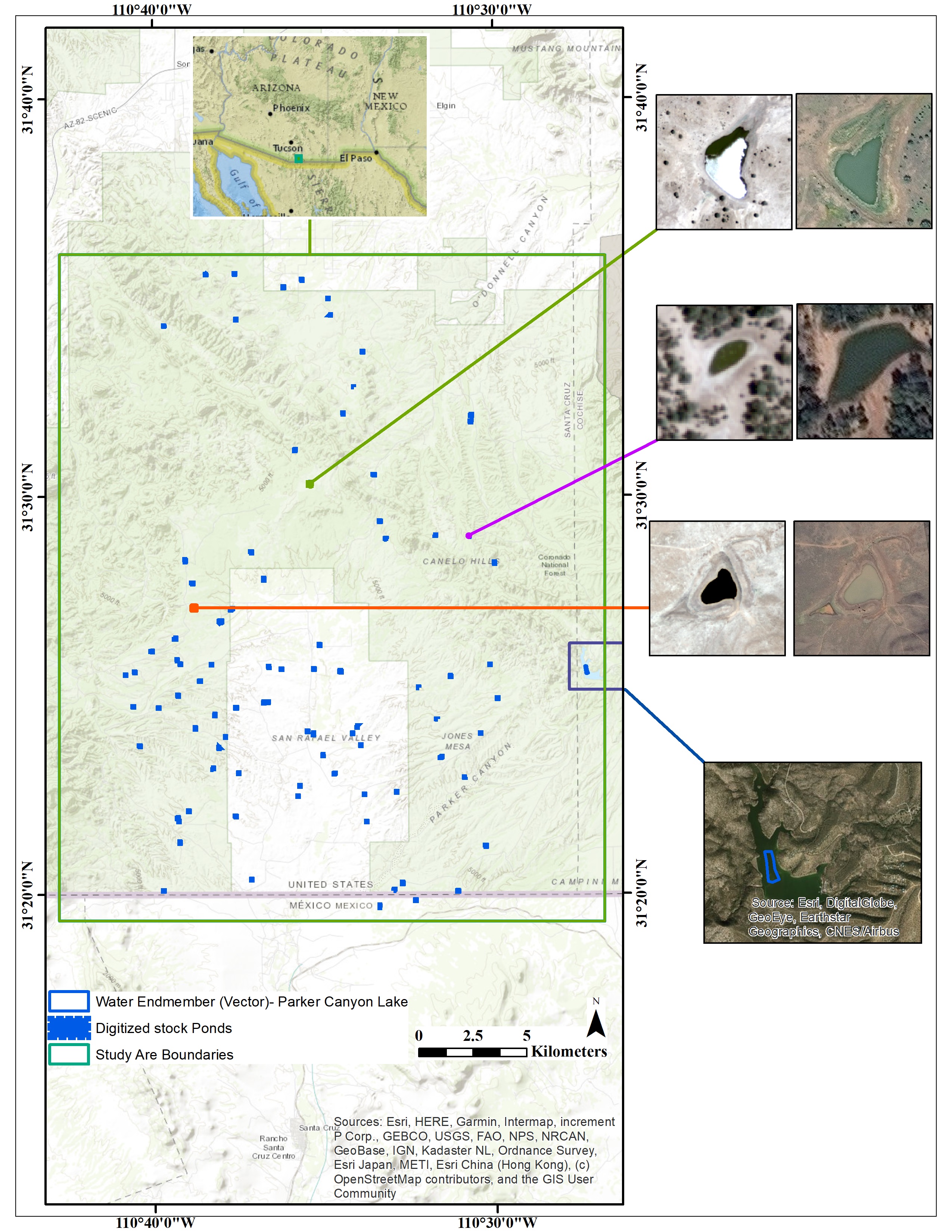
Study area in southern Arizona (USA) showing water endmember location (Parker Canyon Lake; bottom right) and examples of three waterbodies with different sizes and spectral characteristics using June 2007 Landsat 5 TM (left) and September 2018 Landsat 8 OLI (right).
ARMI Organizational Units:
Rocky Mountains, Northern - BiologySouthwest, Arizona - Biology
Topics:
DroughtWater
Place Names:
ArizonaKeywords:
ARMIclimate
drought
ecosystem services
evapotranspiration
habitat alteration
hydroperiod
surface water
trends
water
wetlands