Informative priors can account for location uncertainty in stop-level analyses of the North American Breeding Bird Survey (BBS), allowing fine-scale ecological analyses
Abstract/Summary
Ecologists can learn a lot about species by studying the precise locations in which they do (and do not) occur, but the location information associated with many species records is imprecise. A prominent example of this is the North American Breeding Bird Survey (BBS), in which volunteer observers have surveyed birds at points along consistent routes across the United States for over fifty-five years. As the BBS was designed for large-scale analyses, detailed location information for each bird count is not recorded. We estimate location uncertainty, and the resulting uncertainty in land cover covariates, for the BBS data and present a modeling method that accounts for this uncertainty in a way that opens new possibilities for fine-scale uses of this extensive dataset, unlocking its potential to advance the study of the relationships between birds and their immediate habitat. More broadly, our methods and modeling framework could be used in a variety of situations in which covariate or location uncertainty is a challenge.
Publication details
| Published Date: | 2024-09-14 |
| Outlet/Publisher: | Ornithological Applications |
| Media Format: |

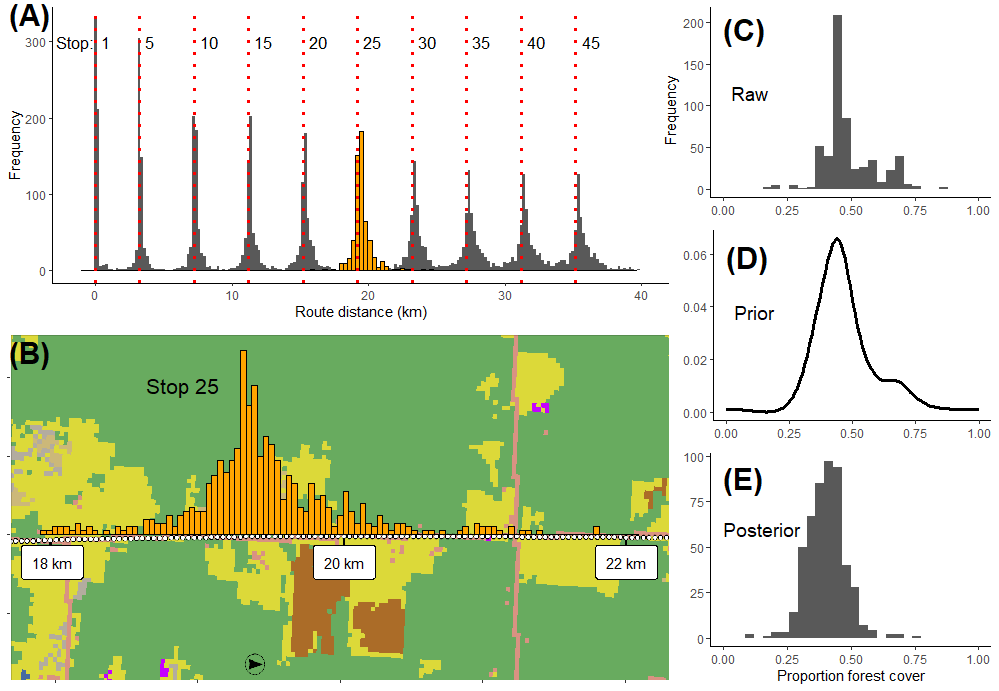
Quantification of stop-location uncertainty and resulting land cover uncertainty for North American Breeding Bird Survey (BBS) stops. Histograms (A) show variation in the locations of selected stops along BBS route lines, based on digitized stop location estimates from 13 states (Figure 1). As an example, histograms show just ten of the 50 calculated stops (number labels), and red vertical dotted lines indicate the hypothetical location of each stop given even 800 m stop spacing along route line
ARMI Organizational Units:
Midwest - BiologyTopics:
ManagementQuantitative Developments
Species and their Ecology
Place Names:
MichiganMinnesota
North America
Wisconsin
Keywords:
Bayesian modelingcovariate uncertainty
informative priors
location uncertainty
species records
